News
NSF Awards SDSC, Arizona State University $1.7 Million for National OpenTopography LiDAR Facility
Published December 10, 2009
|
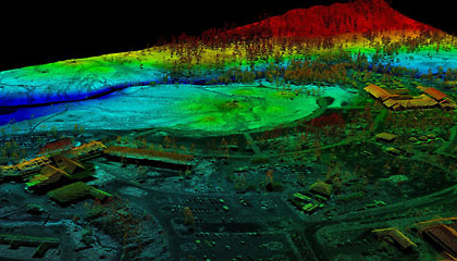
LiDAR point cloud data for the Old Faithful area of Yellowstone National Park. Data source is EarthScope LiDAR hosted by the OpenTopography Facility. Image shows approximately 8.3 million individual LiDAR returns. The historic Old Faithful Inn is the structure at left. The Old Faithful Geyser is in the middle of the image. Credit: Christopher Crosby, SDSC.
|
The San Diego Supercomputer Center (SDSC) at UC San Diego and Arizona State University have been awarded a $1.7 million grant from the National Science Foundation (NSF) to operate an internet-based national data facility for high-resolution topographic data acquired with LiDAR (Light Detection and Ranging) technology. The facility will also provide online processing tools and act as a community repository for information, software and training materials.
The three-year project, which includes a grant of $1.4 million to SDSC and $300,000 to the School of Earth and Space Exploration at Arizona State University, will be based on SDSC's OpenTopography portal, which will be scaled up to a national facility to make topography data available in multiple formats. This includes "raw" LiDAR point cloud data, standard LiDAR-derived digital elevation models, and easily accessible Google Earth products to better serve LiDAR users at various levels of expertise.
OpenTopography currently hosts and distributes a limited number of data sets acquired with funding from the NSF, NASA, and the U.S. Geological Survey (USGS). It is the product of the NSF-funded GEON (GeoSciences Network) project that has developed cyberinfrastructure for the integration of three- and four-dimensional earth science data.
"The fundamental goal of this project is to provide centralized access to community earth science LiDAR topography data," said Christopher Crosby, SDSC's project manager for the OpenTopography Facility. "There is wealth of public domain LiDAR data available, but much of it is not yet easily accessible. We intend to leverage available cyberinfrastructure to make these powerful data sets, as well as online processing tools and knowledge resources, accessible to a large and diverse user community."
Other SDSC researchers contributing to OpenTopography include Viswanath Nandigam, who has been the technical lead on the project since its inception, and Sriram Krishnan, in charge of the project's SOA (service-oriented architecture).
The OpenTopography Facility will be primarily focused on large, community-oriented, scientific data sets, while building collaborations with existing LIDAR topography data providers and hosts such as the USGS and the NSF-funded National Center for Airborne Laser Mapping (NCALM) to link to their data archives and/or to host and distribute their data. An advisory committee representing OpenTopography users will prioritize which data sets are of greatest value to the community.
|
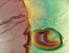
LiDAR digital elevation model (DEM)-derived image of Fish Springs cinder cone and the Owens Valley fault in eastern California produced from OpenTopography-hosted EarthScope LiDAR data. Credit: Christopher Crosby, SDSC. Source: San Diego Supercomputer Center, UC San Diego. |
"LiDAR topography data is revolutionizing the way we study the geomorphic processes acting along the Earth's surface," said Ramon Arrowsmith, associate professor in the School of Earth and Space Exploration at Arizona State University and project co-investigator. "From earthquake hazards research to examining the impact of human development on natural systems, LiDAR is emerging as a fundamental tool."
"High-resolution topographic data collection is burgeoning for research, planning and regulatory activities, yet the massive size of the data sets has made online community access to them difficult," said Chaitan Baru, SDSC Distinguished Scientist and principal investigator for OpenTopography and GEON. "LiDAR is an interesting test case because of those data volumes and the on-demand access our users require, but ultimately the strategies developed in this work could be applied to all types of scientific data over a very wide range of domains."
OpenTopography addresses the basic challenge of how to efficiently manage, archive, distribute process and integrate tens of terabytes of community geospatial data. Many organizations that acquire LiDAR topography do not have the disk space, bandwidth, and in-house expertise necessary to make these data available via the Internet for community-level access and analysis.
The OpenTopography LiDAR Facility is funded under NSF award number 0930731 (SDSC) and 0930643 (ASU).
About SDSC
As an organized research unit of UC San Diego, SDSC is a national leader in creating and providing cyberinfrastructure for data-intensive research. Cyberinfrastructure refers to an accessible and integrated network of computer-based resources and expertise, focused on accelerating scientific inquiry and discovery. SDSC recently doubled its size to 160,000 square feet with a new, energy-efficient building and data center extension, and is a founding member of TeraGrid, the nation's largest open-access scientific discovery infrastructure.
Media Contacts:
Jan Zverina, SDSC Communications
858 534-5111 or
jzverina@sdsc.edu
Warren R. Froelich, SDSC Communications
858 822-3622 or
froelich@sdsc.ed
Categories
Archive
Related Links
School of Earth and Space Exploration, Arizona State University: http://sese.asu.edu
OpenTopography Facility: www.opentopography.org
Geosciences Network (GEON) project: www.geongrid.org
National Science Foundation: www.nsf.gov
UC San Diego: www.ucsd.edu


